Wildlife Conservation Areas
A number of wildlife conservation areas have been established in the CNMI through legislative act, local laws, and regulations by the Division of Fish and Wildlife, which is responsible for the management of these conservation areas and the enforcement of conservation area and wildlife related laws.
Each wildlife conservation area is different in terms of conservation purpose, goals and rules, and they offer a range of opportunities for public enjoyment, including hiking and nature trails, wildlife viewing, hunting and recreation.
Saipan
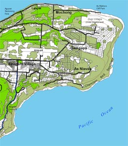
Bird Island Wildlife Conservation Area
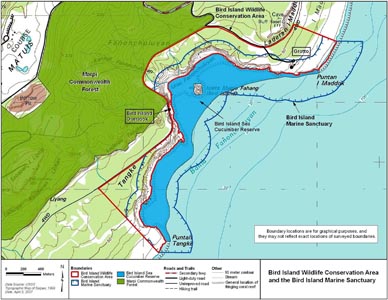
The Bird Island Wildlife Conservation Area was established in 1998 as part of the Commonwealth Mitigation Bank under Public Law 10-84 for purposes of wildlife conservation, to be managed to enhance habitat functions for targeted endangered and threatened species. It is located on the northeastern coast of Saipan and extends from the Bird Island Marine Sanctuary landward. It includes the Grotto and Bird Island Lookout and encompasses an area of 118 hectares.
The Bird Island Wildlife Conservation Area includes two major tourism sites: the Bird Island Overlook and the Grotto. There are also a few roadways and short trails. The primary road accessing the area is a two-lane paved road extending from the Last Command Post/Banzai Cliff area. A paved two-lane road also extends into the northern part of the conservation area where it accesses the Grotto parking lot and Grotto stairs. An unimproved road also extends into the central portion of the wildlife conservation area where it accesses a trailhead and parking area for the 150-meter Bird Island Beach Trail.
The Bird Island Overlook is one of the most popular tourism sites on Saipan. From this overlook, visitors have an expansive view of the Bird Island Wildlife Conservation Area and the Bird Island Marine Conservation Area, including a clear view of Bird Island.
Permissible activities include educational field-trips, documentary filming, hiking, sightseeing, adventure sports and games, and picnics. Other activities that do not detrimentally affect the wildlife may be allowed upon written application to the Director of the Division of Fish and Wildlife.
There is no taking of plants, animals, or wildlife in the conservation area.
Kagman Wildlife Conservation Area
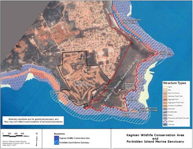
Kagman Wildlife Conservation Area was established in 1998 as part of the Commonwealth Mitigation Bank under Public Law 10-84 for purposes of wildlife conservation, to be managed to enhance habitat functions for targeted endangered and threatened species. It consists of 175 hectares along the eastern shoreline of the Kagman Peninsula and includes the Forbidden Island Overlook. The area and is bounded to the north, east, and south by the Forbidden Island Marine Sanctuary. To the west, it is generally bounded by the Laolao Bay Golf course and Kagman Village.
Within the Kagman Wildlife Conservation Area is an unpaved parking lot near Tank Beach, which is part of the Forbidden Island Marine Sanctuary. The parking lot can be reached via an unpaved road from Kagman village. Another parking lot can be reached via an access road from the conservation area boundary to the Forbidden Island Overlook and spectacular views of Forbidden Island and the rugged coastal cliffs. An unofficial and unmaintained 500-meter trail leads from the access road to the beach near Forbidden Island. The trail is steep and potentially hazardous.
Within the Kagman Wildlife Conservation Area are archaeological sites, including the remnants of ancient Chamorro villages and historic sites from the Japanese and American occupations and wartime battles, including hidden pill boxes at Tank Beach.
Permissible activities within these sanctuaries include educational field trips, documentary filming, hiking, sightseeing, adventure sports and games, and picnics. Other activities that do not detrimentally affect the wildlife may be allowed upon written application to the Director of the Division of Fish and Wildlife.
There is no taking of plants, animals, or wildlife in the conservation area.
Lake Susupe Conservation Area
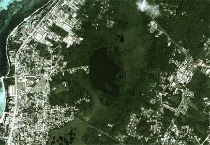
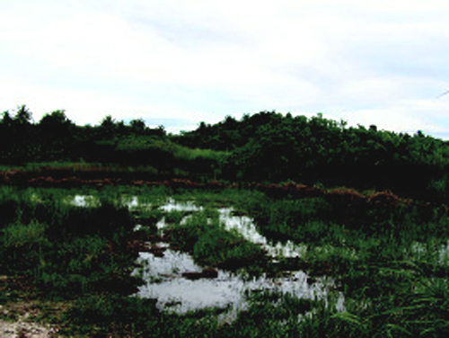
Hagoi Susupi (Lake Susupe) is a small (0.17 sq km), brackish lake near the southwest part of Saipan, surrounded by an extensive marsh area of 2.02 sq km. Together this area is the Susupe Wetland. It accounts for 60% of the wetlands in the CNMI and provides 77% of the remaining habitat for the Mariana common moorhen (Gallinula chloropus guami), a bird listed both Federally as an endangered and locally as a threatened or endangered species. Susupe Wetland is regulated under CNMI Public Law 02-51 for the protection, restoration, and preservation of freshwater wetlands, habitat and species. Through the Saipan Upland Mitigation Bank and with federal funding assistance, DFW was able to purchase about 4.5 hectares of wetland habitat at Hagoi Susupe.
The Susupe wetland is one of the few large freshwater wetlands in the CNMI. It is regulated to preserve, protect, and restore this unique ecosystem that plays an important role in filtering runoff from land to protect coral reefs from sedimentation. Additionally, these wetlands are important sources of freshwater and storm water catchment and harbor rare or unique species.
Access to Hagoi Susupi is currently available only via private property adjacent to the lake, where a pagoda provides visitors with a view of the lake and surrondings.
Megapode Conservation Areas
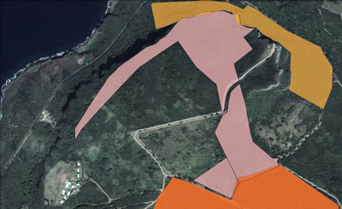
The Nightingale Reed-Warbler Conservation Area and the Micronesian Megapode Conservation Area were established after the CNMI Department of Public Lands' (DPL) formal Section 7 consultation with the U.S. Fish and Wildlife Service as part of the planning process for Marpi Point village homestead development. DPL deeded land to the Department of Lands and Natural Resources to be used for the conservation of these two species that it was determined would be affected by the proposed development.
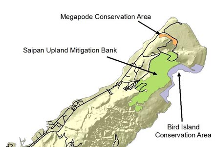
The Micronesian Megapode Conservation Area shown in the gold-shaded area at the top of the map, is one of Saipan's last native limestone forest areas and the natural habitat of the endemic Sansagat (Micronesian Megapode, Megapodius laperou). DPL agreed to set aside 17.6 hectars of native limestone forest to be held in perpetuity for the conservation of the species.
The 31.2 hectar Nightingale Reed-Warbler Conservation Area shown in the reddish area in the middle of the map, was set aside to protect known breeding habitat for Gaga Karisu (Nightingale Reed-Warbler, Acrocephalus luscinia), which is now one of the rarest birds in the world. The conservation area shares a boundary with the Saipan Upland Mitigation Bank, shown in orange at the bottom of the map.
Clearing, construction, recreation or other activities that are incompatible with the protected species are not allowed within the conservation areas.
Saipan Upland Mitigation Bank
The Saipan Upland Mitigation Bank provides a species reserve (Protected Area) for the Federally and locally listed endangered Nightingale Reed-Warblers (Acrocephalus luscinia). Development that impacts the habitat of this species elsewhere can be mitigated through the purchase of credits to protect breeding pairs of birds in the Protected Area. The Protected Area also serves as protected habitat for other threatened and endangered species including the Micronesian Megapode (Megapodius laperouse) and the Mariana Swiftlet (Aerodramus bartschi), and endemic species such as the Collared Kingfisher (Halcyon chloris), Mariana Fruit-dove (Ptilinopus roseicapilla), and Golden White-eye (Cleptornis marchei). Additionally, Mariana Fruit Bat (Pteropus mariannus) and scarce herpetofauna and invertebrates occur within the Protected Area.
The Saipan Upland Mitigation Bank was created in 1998 through CNMI Public Law 10-84 that established the Protected Area* and authorized the creation of the Commonwealth Mitigation Bank to be managed by the Department of Public Lands.
*Bird Island Wildlife Preserve, Kagman Wildlife Conservation Area, and the Marpi Commonwealth Forest.
Costco Park Wetland Mitigation Pond
The Costco Park Wetland Mitigation Pond is located next to the site of the former Price-Costco store, which is now the Joeten Superstore. It serves as an off-site mitigation area to offset the loss of wetland habitat from the construction of the Costco building. It is an example of how developers with projects that impact wetlands may purchase an ecologically similar area elsewhere to be utilized for protection in its place. Thus, we benefit from the economic development of land while simultaneously establishing permanently protected wetland habitat.
The Costco Park Wetland Mitigation Pond was created for wetland mitigation under the Clean Water Act of 1972, It provides habitat for the endangered Mariana Common Moorhen and migratory birds. The wetland is not completely natural. It was engineered to provide wetland habitat year-round by way of a surrounding aquatic moat that contains water all year, even during the dry season. Islands built within the pond are flooded during the wet season, encouraging the dominance of wetland vegetation that is food for waterfowl. As with a natural wetland, this engineered wetland filters sediments and nutrients from runoff and floodwaters.
Rota
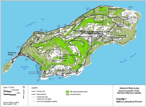
Mariana Crow Conservation Area
The Marianas Crow Conservation Area (MCCA)was created by Division of Fish and Wildlife (DFW) regulation (Subchapter 85-30.4 of the CNMI Administrative Code) in order to "insure appropriate use of the MCCA for the enjoyment and general welfare of the public while protecting the area in its natural state to serve as a refuge for native wildlife, with emphasis on the Mariana Crow."
MCCA is a no-take area for plants and wildlife except by permit from DFW. Excepted is the taking of plants for use in traditional healing practices. No pets or livestock are allowed within the MCCA. Motorized vehicles are not allowed except on the unpaved road to the Pictograph Cave. Trails within the MCCA are open to the public from 30 minutes before sunset to 30 minutes after sunset.
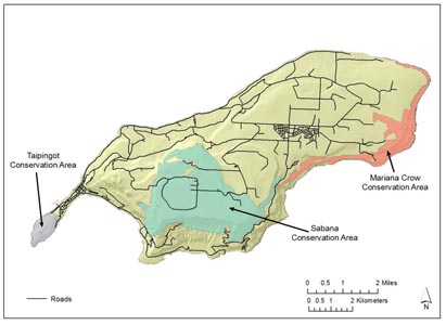
Sabana Protected Area
The Sabana Protected Area is a 15 sq km plateau of mixed small agricultural lots and various types of native forest, including adjacent forested cliff lines. It's encompassing over one-third of the island's land mass and provides habitat for several of endemic species including the Marianas Fruit Bat, Bridled White Eye, Marianas Crow, Sambar Deer, Coconut Crab, and seabirds like Brown Boobies.
The Sabana Protected Area was designated a protected area by First Senatorial District (Rota) Local Law 9-1 in 1994 in order to provide watershed protection, wildlife and forest conservation. It includes the Sabana Watershed Area and Talakhaya, with some areas of private land and homesteads excluded.
I'Chenchon Park Wildlife Conservation Area
I'Chenchon Park Wildlife Conservation Area, also known as the I'Chenchon Bird Sanctuary, was established by Rota Local Law 9-1 for the conservation of wildlife and forest vegetation for the benefit of current residents, future generations and the tourist industry. It is home to a wide variety of nesting seabirds. It includes coastal cliffs and primary limestone forest extending along the entire length of Luta's eastern coastline.
I'Chenchon Park Wildlife Conservation Area is a no-take area for all plant and animal life with the exception of medicinal plants. Any actions that may have an adverse impact on plants and wildlife there are expressly prohibited.
Liyo Conservation Area
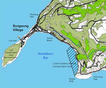
Incorporating Mt. Taipingot, also known as Wedding Cake Mountain because of its layered appearance and flat top, the Liyo Conservation Area was created by Rota Local Law (Title 10: Division 1: Section 1821) in order to conserve the indigenous wildlife and forest vegetation that exists on and around Mt.Taipingot.
The Liyo Conservation Area is a no-take area for all plant and animal life with the exception of medicinal plants. Any actions that may have an adverse impact on plants and wildlife there are expressly prohibited.
Mt. Taipingot is 470 feet above sea level. A 30 to 45-minute hike to the top takes visitors through dense tropical forest populated with a variety of birds to a beautiful view of Songsong village.
As Gani (The Northern Islands)
Guguan, Uracas, Maug and Asuncion Islands
The islands of Guguan, Uracus, Maug and Asuncion are designated as wildlife conservation areas in accordance with 2 CMC § 5104(a)(5) and article XIV(2) of the CNMI Constitution. Landing on these islands is prohibited without prior approval from the Director, except in the case of actual emergency.