Marine Protected Areas
Marine Protected Areas (MPAs) are designated areas in the ocean or nearshore environment which aim to protect living, non-living, cultural and/or historical resources. There are seven Marine Protected Areas (MPAs) in the CNMI, including five fully "No-take" Marine Protected Areas and two Species-specific reserves. These special conservation zones protect our fish, corals, and invertebrates. They serve as safe havens for marine organisms to grow and reproduce in areas free from fishing pressure. Certain activities are restricted within these MPAs, and each area has unique rules.
MPAs in the Commonwealth include marine conservation areas, sanctuaries, and reserves. In the CNMI, MPAs are created via legislative act, local law, or regulation. Special rules applying to marine reserves can be found on the Fishing Regulations Summary page. A quick reference on MPA laws and regulations is available for natural resource managers and MPA stakeholders.
All MPAs are managed by the Division of Fish and Wildlife. These conservation areas differ in terms of goals and purpose, and they offer many opportunities for exploration and enjoyment. Please click on the names of the MPAs below for more information and to view detailed maps of each area.
For the precise location of MPA boundaries, GIS map layers are available courtesy of CNMI Coastal Resources Management.
Mañagaha Marine Conservation Area
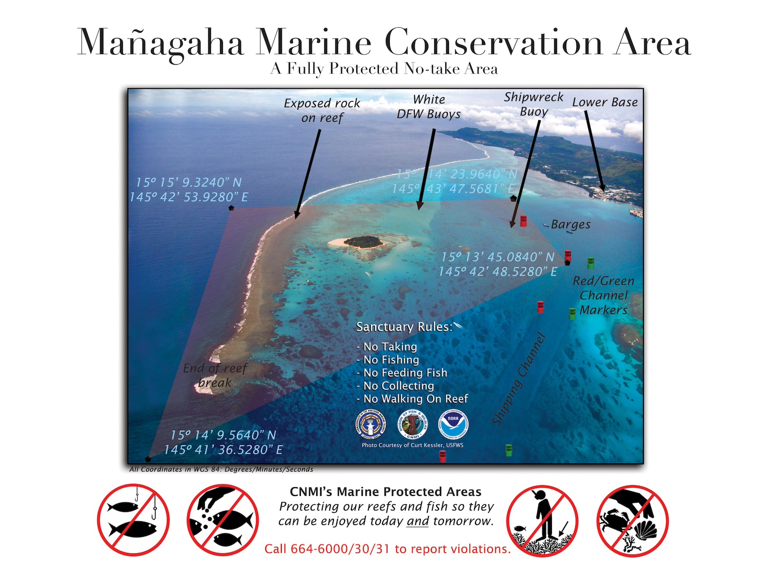
The Mañagaha Marine Conservation Area (MMCA) is a "no-take" area, which surrounds tiny Mañagaha Island on Saipan's western barrier reef. It was created with the enactment of CNMI Public Law 12-12 in order to protect and preserve the natural and cultural resources of the island and surrounding waters, and is currently managed within the guidelines of the Mañagaha Marine Conservation Area Management Plan. Because the MMCA is a "no take" area, it is illegal to catch or remove any species, damage habitat, feed fish, and collect shells, sand or corals.
Mañagaha island is maintained as an uninhabited place and used only for cultural and recreational purposes. The island is highly visited by locals and tourists due to its beautiful recreational shoreline, vibrant nearshore area, and peaceful island atmosphere. It is also the burial site of Carolinian Chief Aghurubw who established the first Carolinian settlement on Saipan during the Spanish colonial period.
Within the Mañagaha Marine Conservation Area's 500 hectares are at least 240 species of hard corals, 31 species of soft corals and sea fans, and more than 100 fish species as well as green sea turtles. The MMCA supports adjacent fisheries by providing a safe-haven for a multitude of fish species to reproduce and grow without pressure from fishing activities.
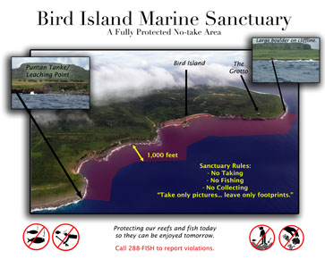
Bird Island Marine Sanctuary
The Bird Island Marine Sanctuary was created along with Forbidden Island Marine Sanctuary by Public Law 12-46
- Promote the concept of conserving and protecting natural resources
- Serve as a natural laboratory for the continued propagation of wildlife and marine species, which gradually and naturally can re-populate depopulated areas
- Provide a laboratory for students, teachers and research groups to study wildlife and marine species
Like the Managaha Marine Conservation Area, the Bird Island Marine Sanctuary is also a "no take" protected area, where fishing, damaging corals, feeding fish, and collecting sand and shells are all prohibited. The Bird Island Marine Sanctuary is currently managed within the framework of the Bird Island Wildlife Conservation Area and Bird Island Marine Sanctuary Management Plan. Located on the northeastern coast of Saipan, this specially protected area includes Bird Island and the Grotto. The marine sanctuary runs along the marine side of the adjacent Bird Island Wildlife Conservation Area which includes the Bird Island Lookout. Together, these two conservation areas encompass 268 hectares of land and ocean.
The Bird Island Overlook is one of the most popular tourism sites on Saipan. From this overlook, visitors have an expansive view of the Bird Island Wildlife Conservation Area and the Bird Island Marine Conservation Area, including a clear view of Bird Island. The internationally renowned Grotto is one of the most popular diving sites on Saipan. Approximately 100 steps lead to the Grotto's sea-level pool in an open cave where an underwater tunnel leads to the open ocean.
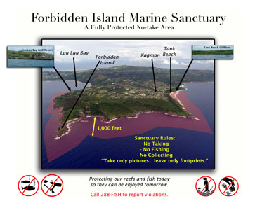
Forbidden Island Marine Sanctuary
The Forbidden Island Marine Sanctuary was created along with Bird Island Marine Sanctuary by Public Law 12-46 in April 2001, in order to:
- Promote the concept of conserving and protecting natural resources
- Serve as a natural laboratory for the continued propagation of wildlife and marine species, which gradually and naturally can re-populate depopulated areas
- Provide a laboratory for students, teachers and research groups to study wildlife and marine species
The Forbidden Island Marine Sanctuary is a "no-take" marine protected area, meaning that human activities such as fishing, feeding fish, and collecting sand and shells are all prohibited. Damaging coral is also prohibited here. The Forbidden Island Marine Sanctuary is managed under the framework of the Kagman Wildlife Conservation area and Forbidden Island Marine Sanctuary Management Plan . The Forbidden Island sanctuary extends 1,000 feet offshore, following the shoreline of the Kagman Wildlife Conservation Area, and includes Tank Beach and Forbidden Island. It is bordered by the Lau Lau Bay Sea Cucumber sanctuary. Sixty percent of the sanctuary shoreline consists of fringing reefs which, at their widest point near Forbidden Island, extend as much as 100 meters from shore. Together the Forbidden Island Sanctuary and the Kagman Wildlife Conservation Area encompass 440 hectares of land and sea.
The Forbidden Island Overlook and the associated beach trail are considered some of the premier ecotourism sites on Saipan due to their striking views of Forbidden Island, as well as the high coastal cliffs and rugged shoreline. Tank Beach is also a popular recreation site for locals.
Sasanhaya Bay Fish Reserve (Luta)
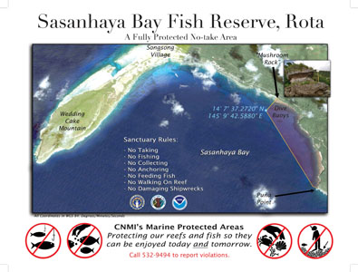
The Sasanhaya Bay Fish Reserve was established in 1994 by Senate Local Bill 9-2 as a marine reserve to preserve the natural beauty, pristine marine environment and the historical WW II wreckage in Rota's Sasanhaya Bay. It is the only "no-take" Marine Protected Area on Rota. Prohibited activities within the reserve include fishing, taking any marine animals or plants, feeding fish, damaging habitat, interfering with WW II historical sites, and collecting shells, sand or coral.
The reserve is bounded from the north by Mushroom rock, and at the south by Puña Point. It extends 1000 feet seaward from the mean high tide line. The Coral Gardens found within the Sasanhaya Bay Fish reserve are some of the most luxuriant areas of coral growth in the CNMI and attract SCUBA divers from all over the world.
Tinian Marine Reserve
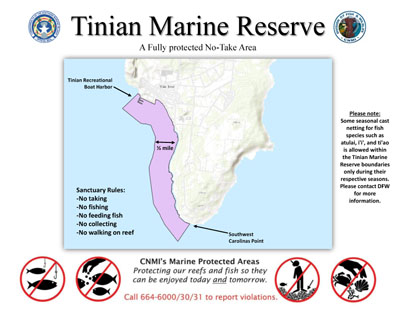
The Tinian Marine Reserve was established by Public Law 15-90 and amended by Public Law 17-14 in order to preserve the natural and pristine beauty of this area of Tinian's marine environment and to regulate the fishing and harvesting of marine life there. It is a "no-take" reserve, and is the sole Marine Protected Area located on the island of Tinian.
The reserve is located from the Southwest Carolinas Point to the Tinian Recreational Boat Harbor, specifically encompassing all the areas from Tachogna Beach, Taga Beach, YCC Beach, Kammer Beach, and Tinian Harbor, from the high-tide mark on shore to one-half mile out to the reef.
Prohibited activities within the Tinian Marine Reserve include fishing, taking any marine animals or plants, feeding fish, damaging habitat, interfering with WW II historical sites, and collecting shells, sand or coral, except that seasonal fish such as atulai, i'i', and ti'ao may be removed only during their respective seasons. Any other activities that are exploitative or destructive to the marine life or to any historical value of the area are also prohibited.
Lau Lau Bay Sea Cucumber Sanctuary
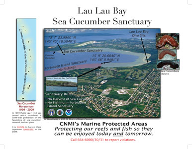
The Lau Lau Bay Sea Cucumber Sanctuary was established by Public Law 11-63 and CNMI Administrative Code §85-30.1-420, and is located on the eastern side of Saipan Island. Beginning at Puntan Hakmang and extending south to Puntan Dandan, the Lau Lau Bay Sea Cucumber Sanctuary extends from the mean high water mark seaward to the 40-foot depth contour and borders Forbidden Island Sanctuary's eastern boundary.
There is currently a moratorium in effect for sea cucumber harvesting throughout the CNMI. This reserve exists in the event that the moratorium is lifted. The moratorium was enacted after a commercial fishery on Saipan and Rota heavily depleted the surf redfish (Actinopyga mauritiana) resources in the 1990's.
In order to restore surf redfish populations and establish a sustainable fishery, the Lau Lau Bay Sea Cucumber Sanctuary was created and a no-take moratorium was established for all the CNMI to give the resource time to recover.
Lighthouse Reef Trochus Sanctuary
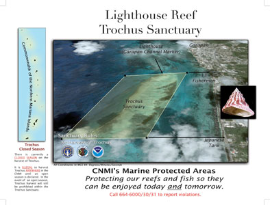
The Lighthouse Reef Trochus Sanctuary was established by CNMI Administrative Code §85-30.1-420. The Sanctuary area encompasses the barrier reef from the Garapan channel marker (lighthouse) south for one mile. It extends from the inshore edge of the reef to the forty-foot depth contour offshore.
The topshell trochus (Trochus niloticus), was introduced to the Mariana Islands in 1938. From 1947-1976, trochus harvest was restricted to two weeks a year. From 1976 to 1981, harvest was unrestricted. In 1981 the Division of Fish and Wildlife by its regulatory authority , put a CNMI-wide moratorium on trochus harvest into effect, and established the Lighthouse Reef Trochus Sanctuary. The moratorium on removal of trochus remains in effect today. This sanctuary exists so that, in the event that the trochus moratorium is lifted, a safe haven for trochus growth and reproduction will already be in effect.